Sample map and reference data: https://glad.geog.umd.edu/Potapov/Global_Crop/reference_sample_data.csv
Map data provided for each sample and each four-year interval (2000-2003, 2004-2007, 2008-2011, 2012-2015, and 2016-2019) referred to by the last year of the interval (2003, ... ,2019). Map values: 1 - crop detected, 0 - no crop detection.
Reference data based on visual image interpretation. Reference categories:
- SC - stable crop (crop observed in 2000-2003 and 2016-2019)
- SNC - stable non-crop
- CG - crop gain (crop established after year 2000)
- CL - crop loss (crop observed in 2000-2003, and was converted to other land use by 2019)
Sample analysis was performed separately by seven regions selected as population of the 1×1° Landsat ARD tiles within continents and national boundaries. The to access sample data, use the link to a specific region:
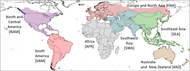
Africa [AFR]: https://glad.geog.umd.edu/Potapov/Global_Crop/AFR/AFR_index.html
Southwest Asia [SWA]: https://glad.geog.umd.edu/Potapov/Global_Crop/SWA/SWA_index.html
Australia and New Zealand [ANZ]: https://glad.geog.umd.edu/Potapov/Global_Crop/ANZ/ANZ_index.html
Southeast Asia [SEA]: https://glad.geog.umd.edu/Potapov/Global_Crop/SEA/SEA_index.html
Europe and North Asia [ENA]: https://glad.geog.umd.edu/Potapov/Global_Crop/ENA/ENA_index.html
North and Central America [NAM]: https://glad.geog.umd.edu/Potapov/Global_Crop/NAM/NAM_index.html
South America [SAM]: https://glad.geog.umd.edu/Potapov/Global_Crop/SAM/SAM_index.html
Sample data interface description:

A - the sample Region and ID.
B - the link to Google Earth interface (provides sample outline).
C - Landsat ARD 16-day clear-sky NDVI and shortwave infrared band (1.6 µm) normalized surface reflectance for the sample pixel. NDVI value (-1 to 1) scaled to the range 0-2, and reflectance (0 to 1) scaled to range 1-3.
D - Landsat interquartile means for each time interval (2000-2003, 2004-2007, 2008-2011, 2012-2015, 2016-2019). Band combination SWIR (1.6 µm) / NIR/ Red.
E - Landsat maximum NDVI composite for each time interval, band combination NIR / SWIR SWIR (1.6 µm) / SWIR (2.2 µm).
F - Landsat snow-free season amplitude, band combination NIR / SWIR (2.2 µm) / NDVI. In each Landsat each composite, D-F, selected sample pixel outlined in red.