|
Landsat TM (1990)

zoom |
|
|
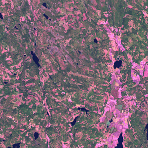
Path: 196; Row: 018
Data within tile: 100.0
|
|
Date: 1987/07/23
Cloud cover: 0.1
|
|
NDVI at image date: 100% of annual maximum
 Downolad image data [zip] Downolad image data [zip]
|
|

zoom |
|
|
Path: 197; Row: 018
Data within tile: 100.0
|
|
Date: 1987/08/31
Cloud cover: 0.9
|
|
NDVI at image date: 98% of annual maximum
Downolad image data [zip]
|
|
|
|
|
Landsat ETM+ (2000)

zoom |
|
|
Path: 196; Row: 018
Data within tile: 100.0
|
|
Date: 2001/07/05
Cloud cover: 6.3
|
|
NDVI at image date: 99% of annual maximum
Downolad image data [zip]
|
|

zoom |
|
|
Path: 197; Row: 018
Data within tile: 100.0
|
|
Date: 2000/05/06
Cloud cover: 0.0
|
|
NDVI at image date: 84% of annual maximum
Downolad image data [zip]
|
|
|
|
|
Landsat ETM+ (2005)

zoom |
|
|
Path: 196; Row: 018
Data within tile: 100.0
|
|
Date: 2007/08/23
Cloud cover: 0.0
|
|
NDVI at image date: 100% of annual maximum
Downolad image data [zip]
|
|

zoom |
|
|
Path: 197; Row: 018
Data within tile: 76.9
|
|
Date: 2007/06/11
Cloud cover: 0.7
|
|
NDVI at image date: 99% of annual maximum
Downolad image data [zip]
|
|

zoom |
|
|
Path: 197; Row: 018
Data within tile: 77.5
|
|
Date: 2007/10/17
Cloud cover: 0.0
|
|
NDVI at image date: 89% of annual maximum
Downolad image data [zip]
|
|
|