|
Landsat TM (1990)

zoom |
|
|
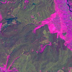
Path: 185; Row: 028
Data within tile: 100.0
|
|
Date: 1988/08/29
Cloud cover: 0.0
|
|
NDVI at image date: 93% of annual maximum
 Downolad image data [zip] Downolad image data [zip]
|
|

zoom |
|
|
Path: 186; Row: 028
Data within tile: 100.0
|
|
Date: 1992/07/30
Cloud cover: 0.0
|
|
NDVI at image date: 95% of annual maximum
Downolad image data [zip]
|
|
|
|
|
Landsat ETM+ (2000)

zoom |
|
|
Path: 185; Row: 028
Data within tile: 100.0
|
|
Date: 2000/08/22
Cloud cover: 0.0
|
|
NDVI at image date: 95% of annual maximum
Downolad image data [zip]
|
|

zoom |
|
|
Path: 186; Row: 028
Data within tile: 100.0
|
|
Date: 2000/09/30
Cloud cover: 0.0
|
|
NDVI at image date: 85% of annual maximum
Downolad image data [zip]
|
|
|
|
|
Landsat ETM+ (2005)

zoom |
|
|
Path: 186; Row: 028
Data within tile: 71.8
|
|
Date: 2007/08/17
Cloud cover: 0.0
|
|
NDVI at image date: 95% of annual maximum
Downolad image data [zip]
|
|

zoom |
|
|
Path: 186; Row: 028
Data within tile: 71.9
|
|
Date: 2007/09/02
Cloud cover: 4.5
|
|
NDVI at image date: 93% of annual maximum
Downolad image data [zip]
|
|
|