|
Landsat TM (1990)

zoom |
|
|
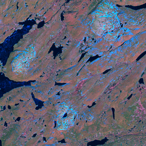
Path: 188; Row: 012
Data within tile: 100.0
|
|
Date: 1992/06/10
Cloud cover: 0.8
|
|
NDVI at image date: 88% of annual maximum
 Downolad image data [zip] Downolad image data [zip]
|
|

zoom |
|
|
Path: 189; Row: 011
Data within tile: 100.0
|
|
Date: 1989/08/04
Cloud cover: 4.7
|
|
NDVI at image date: 98% of annual maximum
Downolad image data [zip]
|
|

zoom |
|
|
Path: 190; Row: 011
Data within tile: 100.0
|
|
Date: 1993/07/13
Cloud cover: 0.0
|
|
NDVI at image date: 100% of annual maximum
Downolad image data [zip]
|
|
|
|
|
Landsat ETM+ (2000)

zoom |
|
|
Path: 188; Row: 012
Data within tile: 100.0
|
|
Date: 2002/05/29
Cloud cover: 6.7
|
|
NDVI at image date: 74% of annual maximum
Downolad image data [zip]
|
|

zoom |
|
|
Path: 190; Row: 011
Data within tile: 100.0
|
|
Date: 2001/09/13
Cloud cover: 42.4
|
|
NDVI at image date: 92% of annual maximum
Downolad image data [zip]
|
|

zoom |
|
|
Path: 190; Row: 011
Data within tile: 100.0
|
|
Date: 2002/05/27
Cloud cover: 34.8
|
|
NDVI at image date: 74% of annual maximum
Downolad image data [zip]
|
|
|
|
|
Landsat ETM+ (2005)

zoom |
|
|
Path: 190; Row: 011
Data within tile: 67.7
|
|
Date: 2004/07/19
Cloud cover: 0.0
|
|
NDVI at image date: 100% of annual maximum
Downolad image data [zip]
|
|

zoom |
|
|
Path: 190; Row: 011
Data within tile: 67.9
|
|
Date: 2005/07/06
Cloud cover: 0.0
|
|
NDVI at image date: 94% of annual maximum
Downolad image data [zip]
|
|
|