Global Forest Resources Assessment

Food and Agriculture Organization of the UN
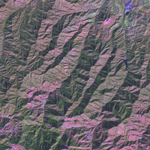
GIScCE, South Dakota State University


e033n35


Location


35° N; 33° E
Asia; Cyprus (Nicosia)
Elevation of the tile center point: 734 m
Water consist 0.0% of block area


Biome/ecoregion


Mediterranean Forests, Woodlands & Scrub biome
Cyprus Mediterranean forests ecoregion


External information resources


The Degree Confluence Project information


Tile outlines


 Tile outline 10x10km and 20x20km [KMZ]
 Tile outline 10x10km [SHP]
 Tile outline 20x20km [SHP]


Climate and Phenology


Köppen Climate Classification System


Humid Middle Latitude, summer dry, hot summer


Temperature/Precipitation


Max temperature of warmest month (C°)

33

Min temperature of coldest month (C°)

3

Annual precipitation (mm)

909


Phenology data

(MODIS-derived Normalized Difference Vegetation Index)


Maximum annual NDVI: 0.61

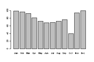
           Monthly NDVI (percent of maximum annual NDVI)


Land Cover Data


MODIS Tree canopy cover


                  Tree canopy cover

         0%

100%


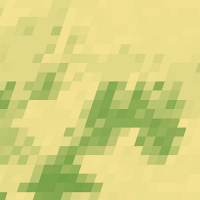
      Tree canopy cover within the tile

mean

14.9%

median

10%

maximum

53%


Bare ground percent within the tile: 6.5%


 Download MODIS-derived tree canopy cover
    and SRTM water mask [GeoTIF]