|
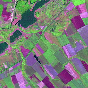
Landsat TM (1990)

zoom |
|
|
Path: 176; Row: 025
Data within tile: 100.0
|
|
Date: 1988/09/23
Cloud cover: 64.4
|
|
NDVI at image date: 68% of annual maximum
 Downolad image data [zip] Downolad image data [zip]
|
|

zoom |
|
|
Path: 176; Row: 025
Data within tile: 100.0
|
|
Date: 1989/05/29
Cloud cover: 0.6
|
|
NDVI at image date: 93% of annual maximum
Downolad image data [zip]
|
|

zoom |
|
|
Path: 177; Row: 025
Data within tile: 99.9
|
|
Date: 1988/08/21
Cloud cover: 0.3
|
|
NDVI at image date: 84% of annual maximum
Downolad image data [zip]
|
|

zoom |
|
|
Path: 177; Row: 025
Data within tile: 65.5
|
|
Date: 1992/09/01
Cloud cover: 0.3
|
|
NDVI at image date: 76% of annual maximum
Downolad image data [zip]
|
|
|
|
|
Landsat ETM+ (2000)

zoom |
|
|
Path: 176; Row: 025
Data within tile: 100.0
|
|
Date: 2001/07/25
Cloud cover: 0.0
|
|
NDVI at image date: 99% of annual maximum
Downolad image data [zip]
|
|

zoom |
|
|
Path: 177; Row: 025
Data within tile: 81.9
|
|
Date: 2001/07/16
Cloud cover: 0.0
|
|
NDVI at image date: 99% of annual maximum
Downolad image data [zip]
|
|
|
|
|
Landsat ETM+ (2005)

zoom |
|
|
Path: 176; Row: 025
Data within tile: 100.0
|
|
Date: 2007/05/23
Cloud cover: 0.0
|
|
NDVI at image date: 87% of annual maximum
Downolad image data [zip]
|
|

zoom |
|
|
Path: 177; Row: 025
Data within tile: 90.3
|
|
Date: 2007/08/18
Cloud cover: 0.0
|
|
NDVI at image date: 84% of annual maximum
Downolad image data [zip]
|
|
|