|
Landsat TM (1990)

zoom |
|
|
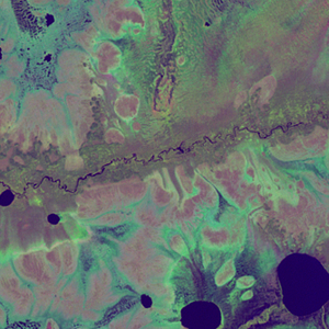
Path: 161; Row: 017
Data within tile: 100.0
|
|
Date: 1988/06/26
Cloud cover: 0.5
|
|
NDVI at image date: 98% of annual maximum
 Downolad image data [zip] Downolad image data [zip]
|
|

zoom |
|
|
Path: 163; Row: 017
Data within tile: 35.5
|
|
Date: 1986/06/27
Cloud cover: 0.0
|
|
NDVI at image date: 98% of annual maximum
Downolad image data [zip]
|
|
|
|
|
Landsat ETM+ (2000)

zoom |
|
|
Path: 161; Row: 017
Data within tile: 100.0
|
|
Date: 2002/07/03
Cloud cover: 0.0
|
|
NDVI at image date: 98% of annual maximum
Downolad image data [zip]
|
|

zoom |
|
|
Path: 163; Row: 017
Data within tile: 97.9
|
|
Date: 2002/07/01
Cloud cover: 0.0
|
|
NDVI at image date: 98% of annual maximum
Downolad image data [zip]
|
|
|
|
|
Landsat ETM+ (2005)

zoom |
|
|
Path: 161; Row: 017
Data within tile: 65.0
|
|
Date: 2006/08/15
Cloud cover: 0.0
|
|
NDVI at image date: 94% of annual maximum
Downolad image data [zip]
|
|

zoom |
|
|
Path: 163; Row: 017
Data within tile: 100.0
|
|
Date: 2004/08/07
Cloud cover: 0.0
|
|
NDVI at image date: 97% of annual maximum
Downolad image data [zip]
|
|
|