|
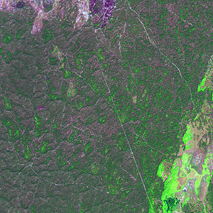
Landsat TM (1990)

zoom |
|
|
Path: 149; Row: 025
Data within tile: 100.0
|
|
Date: 1990/06/20
Cloud cover: 0.0
|
|
NDVI at image date: 82% of annual maximum
 Downolad image data [zip] Downolad image data [zip]
|
|

zoom |
|
|
Path: 150; Row: 024
Data within tile: 100.0
|
|
Date: 1989/07/26
Cloud cover: 0.0
|
|
NDVI at image date: 86% of annual maximum
Downolad image data [zip]
|
|
|
|
|
Landsat ETM+ (2000)

zoom |
|
|
Path: 149; Row: 025
Data within tile: 100.0
|
|
Date: 2000/08/26
Cloud cover: 0.0
|
|
NDVI at image date: 86% of annual maximum
Downolad image data [zip]
|
|

zoom |
|
|
Path: 150; Row: 024
Data within tile: 100.0
|
|
Date: 2001/08/04
Cloud cover: 0.0
|
|
NDVI at image date: 86% of annual maximum
Downolad image data [zip]
|
|
|
|
|
Landsat ETM+ (2005)

zoom |
|
|
Path: 149; Row: 025
Data within tile: 100.0
|
|
Date: 2005/07/07
Cloud cover: 0.3
|
|
NDVI at image date: 84% of annual maximum
Downolad image data [zip]
|
|

zoom |
|
|
Path: 150; Row: 024
Data within tile: 100.0
|
|
Date: 2007/08/29
Cloud cover: 0.0
|
|
NDVI at image date: 90% of annual maximum
Downolad image data [zip]
|
|
|