|
Landsat TM (1990)

zoom |
|
|
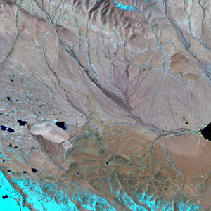
Path: 139; Row: 035
Data within tile: 100.0
|
|
Date: 1989/11/02
Cloud cover: 1.2
|
|
NDVI at image date: 50% of annual maximum
 Downolad image data [zip] Downolad image data [zip]
|
|

zoom |
|
|
Path: 139; Row: 035
Data within tile: 100.0
|
|
Date: 1994/09/29
Cloud cover: 7.3
|
|
NDVI at image date: 75% of annual maximum
Downolad image data [zip]
|
|

zoom |
|
|
Path: 140; Row: 035
Data within tile: 82.0
|
|
Date: 1990/11/12
Cloud cover: 9.4
|
|
NDVI at image date: 50% of annual maximum
Downolad image data [zip]
|
|
|
|
|
Landsat ETM+ (2000)

zoom |
|
|
Path: 139; Row: 035
Data within tile: 100.0
|
|
Date: 2000/10/07
Cloud cover: 6.3
|
|
NDVI at image date: 61% of annual maximum
Downolad image data [zip]
|
|

zoom |
|
|
Path: 140; Row: 035
Data within tile: 100.0
|
|
Date: 1999/08/25
Cloud cover: 15.2
|
|
NDVI at image date: 96% of annual maximum
Downolad image data [zip]
|
|
|
|
|
Landsat ETM+ (2005)

zoom |
|
|
Path: 139; Row: 035
Data within tile: 100.0
|
|
Date: 2005/08/02
Cloud cover: 1.1
|
|
NDVI at image date: 96% of annual maximum
Downolad image data [zip]
|
|

zoom |
|
|
Path: 140; Row: 035
Data within tile: 100.0
|
|
Date: 2007/07/22
Cloud cover: 30.4
|
|
NDVI at image date: 100% of annual maximum
Downolad image data [zip]
|
|
|