|
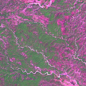
Landsat TM (1990)

zoom |
|
|
Path: 134; Row: 044
Data within tile: 100.0
|
|
Date: 1989/02/08
Cloud cover: 4.8
|
|
NDVI at image date: 82% of annual maximum
 Downolad image data [zip] Downolad image data [zip]
|
|

zoom |
|
|
Path: 134; Row: 044
Data within tile: 100.0
|
|
Date: 1991/02/22
Cloud cover: 64.9
|
|
NDVI at image date: 71% of annual maximum
Downolad image data [zip]
|
|
|
|
|
Landsat ETM+ (2000)

zoom |
|
|
Path: 134; Row: 044
Data within tile: 100.0
|
|
Date: 2000/02/23
Cloud cover: 0.0
|
|
NDVI at image date: 71% of annual maximum
Downolad image data [zip]
|
|
|
|
|
Landsat ETM+ (2005)

zoom |
|
|
Path: 134; Row: 044
Data within tile: 100.0
|
|
Date: 2005/02/04
Cloud cover: 0.0
|
|
NDVI at image date: 82% of annual maximum
Downolad image data [zip]
|
|
|