|
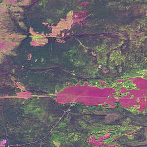
Landsat TM (1990)

zoom |
|
|
Path: 140; Row: 021
Data within tile: 100.0
|
|
Date: 1990/07/07
Cloud cover: 0.0
|
|
NDVI at image date: 99% of annual maximum
 Downolad image data [zip] Downolad image data [zip]
|
|

zoom |
|
|
Path: 140; Row: 021
Data within tile: 100.0
|
|
Date: 1990/08/08
Cloud cover: 4.9
|
|
NDVI at image date: 97% of annual maximum
Downolad image data [zip]
|
|

zoom |
|
|
Path: 141; Row: 021
Data within tile: 100.0
|
|
Date: 1991/05/14
Cloud cover: 0.0
|
|
NDVI at image date: 76% of annual maximum
Downolad image data [zip]
|
|

zoom |
|
|
Path: 141; Row: 021
Data within tile: 100.0
|
|
Date: 1991/06/15
Cloud cover: 0.0
|
|
NDVI at image date: 99% of annual maximum
Downolad image data [zip]
|
|
|
|
|
Landsat ETM+ (2000)

zoom |
|
|
Path: 140; Row: 021
Data within tile: 100.0
|
|
Date: 2000/08/27
Cloud cover: 0.0
|
|
NDVI at image date: 93% of annual maximum
Downolad image data [zip]
|
|

zoom |
|
|
Path: 141; Row: 021
Data within tile: 100.0
|
|
Date: 2000/07/01
Cloud cover: 1.6
|
|
NDVI at image date: 99% of annual maximum
Downolad image data [zip]
|
|

zoom |
|
|
Path: 141; Row: 021
Data within tile: 100.0
|
|
Date: 2002/05/04
Cloud cover: 0.7
|
|
NDVI at image date: 65% of annual maximum
Downolad image data [zip]
|
|
|
|
|
Landsat ETM+ (2005)

zoom |
|
|
Path: 140; Row: 021
Data within tile: 100.0
|
|
Date: 2007/09/08
Cloud cover: 0.0
|
|
NDVI at image date: 85% of annual maximum
Downolad image data [zip]
|
|
|