|
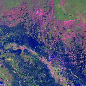
Landsat TM (1990)

zoom |
|
|
Path: 127; Row: 050
Data within tile: 100.0
|
|
Date: 1990/11/17
Cloud cover: 0.0
|
|
NDVI at image date: 84% of annual maximum
 Downolad image data [zip] Downolad image data [zip]
|
|

zoom |
|
|
Path: 128; Row: 050
Data within tile: 67.2
|
|
Date: 1990/01/08
Cloud cover: 0.0
|
|
NDVI at image date: 60% of annual maximum
Downolad image data [zip]
|
|
|
|
|
Landsat ETM+ (2000)

zoom |
|
|
Path: 127; Row: 050
Data within tile: 100.0
|
|
Date: 2000/11/04
Cloud cover: 0.0
|
|
NDVI at image date: 91% of annual maximum
Downolad image data [zip]
|
|

zoom |
|
|
Path: 128; Row: 050
Data within tile: 98.7
|
|
Date: 2002/02/18
Cloud cover: 0.0
|
|
NDVI at image date: 47% of annual maximum
Downolad image data [zip]
|
|
|
|
|
Landsat ETM+ (2005)

zoom |
|
|
Path: 127; Row: 050
Data within tile: 100.0
|
|
Date: 2006/12/15
Cloud cover: 0.0
|
|
NDVI at image date: 70% of annual maximum
Downolad image data [zip]
|
|

zoom |
|
|
Path: 128; Row: 050
Data within tile: 95.0
|
|
Date: 2006/11/04
Cloud cover: 0.2
|
|
NDVI at image date: 91% of annual maximum
Downolad image data [zip]
|
|
|