|
Landsat TM (1990)

zoom |
|
|
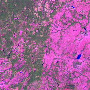
Path: 126; Row: 049
Data within tile: 100.0
|
|
Date: 1989/12/25
Cloud cover: 0.0
|
|
NDVI at image date: 67% of annual maximum
 Downolad image data [zip] Downolad image data [zip]
|
|

zoom |
|
|
Path: 127; Row: 049
Data within tile: 37.5
|
|
Date: 1992/11/06
Cloud cover: 30.1
|
|
NDVI at image date: 85% of annual maximum
Downolad image data [zip]
|
|
|
|
|
Landsat ETM+ (2000)

zoom |
|
|
Path: 126; Row: 049
Data within tile: 100.0
|
|
Date: 2000/11/29
Cloud cover: 0.0
|
|
NDVI at image date: 78% of annual maximum
Downolad image data [zip]
|
|

zoom |
|
|
Path: 127; Row: 049
Data within tile: 96.0
|
|
Date: 2000/11/04
Cloud cover: 0.0
|
|
NDVI at image date: 85% of annual maximum
Downolad image data [zip]
|
|
|
|
|
Landsat ETM+ (2005)

zoom |
|
|
Path: 126; Row: 049
Data within tile: 100.0
|
|
Date: 2006/11/14
Cloud cover: 0.0
|
|
NDVI at image date: 85% of annual maximum
Downolad image data [zip]
|
|

zoom |
|
|
Path: 127; Row: 049
Data within tile: 65.8
|
|
Date: 2006/11/13
Cloud cover: 0.1
|
|
NDVI at image date: 85% of annual maximum
Downolad image data [zip]
|
|
|