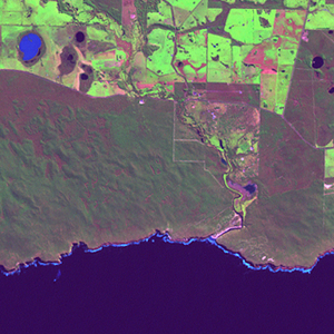
Global Forest Resources Assessment

Food and Agriculture Organization of the UN
GIScCE, South Dakota State University


e137s36


Location


36° S; 137° E
Oceania; Australia (South Australia)
Elevation of the tile center point: 34 m
Water consist 23.6% of block area


Biome/ecoregion


Mediterranean Forests, Woodlands & Scrub biome
Mount Lofty woodlands ecoregion


External information resources


The Degree Confluence Project information


Tile outlines


 Tile outline 10x10km and 20x20km [KMZ]
 Tile outline 10x10km [SHP]
 Tile outline 20x20km [SHP]


Landsat TM (1990)


     zoom

Path: 098; Row: 085


Data within tile: 100.0


Date: 1989/10/18


Cloud cover: 0.7


NDVI at image date: 84% of annual maximum


 Downolad image data [zip]


Landsat ETM+ (2000)


     zoom

Path: 098; Row: 085


Data within tile: 100.0


Date: 2000/08/05


Cloud cover: 1.0


NDVI at image date: 99% of annual maximum


 Downolad image data [zip]


Landsat ETM+ (2005)


     zoom

Path: 098; Row: 085


Data within tile: 100.0


Date: 2006/08/30


Cloud cover: 0.0


NDVI at image date: 94% of annual maximum


 Downolad image data [zip]