|
Landsat TM (1990)

zoom |
|
|
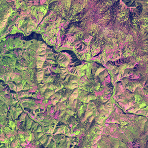
Path: 108; Row: 025
Data within tile: 100.0
|
|
Date: 1989/06/10
Cloud cover: 43.2
|
|
NDVI at image date: 95% of annual maximum
 Downolad image data [zip] Downolad image data [zip]
|
|

zoom |
|
|
Path: 108; Row: 025
Data within tile: 100.0
|
|
Date: 1989/08/05
Cloud cover: 0.1
|
|
NDVI at image date: 100% of annual maximum
Downolad image data [zip]
|
|

zoom |
|
|
Path: 109; Row: 024
Data within tile: 100.0
|
|
Date: 1989/06/17
Cloud cover: 2.1
|
|
NDVI at image date: 95% of annual maximum
Downolad image data [zip]
|
|
|
|
|
Landsat ETM+ (2000)

zoom |
|
|
Path: 108; Row: 025
Data within tile: 100.0
|
|
Date: 2002/06/14
Cloud cover: 0.0
|
|
NDVI at image date: 95% of annual maximum
Downolad image data [zip]
|
|

zoom |
|
|
Path: 109; Row: 024
Data within tile: 100.0
|
|
Date: 1999/10/03
Cloud cover: 4.5
|
|
NDVI at image date: 69% of annual maximum
Downolad image data [zip]
|
|
|
|
|
Landsat ETM+ (2005)

zoom |
|
|
Path: 108; Row: 025
Data within tile: 100.0
|
|
Date: 2004/09/23
Cloud cover: 0.0
|
|
NDVI at image date: 89% of annual maximum
Downolad image data [zip]
|
|

zoom |
|
|
Path: 109; Row: 024
Data within tile: 100.0
|
|
Date: 2006/08/19
Cloud cover: 2.1
|
|
NDVI at image date: 100% of annual maximum
Downolad image data [zip]
|
|
|