|
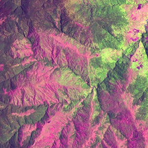
Landsat TM (1990)

zoom |
|
|
Path: 096; Row: 066
Data within tile: 100.0
|
|
Date: 1990/03/28
Cloud cover: 0.0
|
|
NDVI at image date: 84% of annual maximum
 Downolad image data [zip] Downolad image data [zip]
|
|
|
|
|
Landsat ETM+ (2000)

zoom |
|
|
Path: 096; Row: 066
Data within tile: 100.0
|
|
Date: 2001/03/03
Cloud cover: 0.0
|
|
NDVI at image date: 79% of annual maximum
Downolad image data [zip]
|
|
|
|
|
Landsat ETM+ (2005)

zoom |
|
|
Path: 096; Row: 066
Data within tile: 91.3
|
|
Date: 2004/11/06
Cloud cover: 29.8
|
|
NDVI at image date: 89% of annual maximum
Downolad image data [zip]
|
|

zoom |
|
|
Path: 096; Row: 066
Data within tile: 92.7
|
|
Date: 2004/12/08
Cloud cover: 0.0
|
|
NDVI at image date: 88% of annual maximum
Downolad image data [zip]
|
|
|