|
Landsat TM (1990)

zoom |
|
|
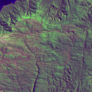
Path: 075; Row: 093
Data within tile: 100.0
|
|
Date: 1989/04/15
Cloud cover: 0.0
|
|
NDVI at image date: 94% of annual maximum
 Downolad image data [zip] Downolad image data [zip]
|
|

zoom |
|
|
Path: 076; Row: 093
Data within tile: 100.0
|
|
Date: 1988/11/13
Cloud cover: 46.0
|
|
NDVI at image date: 94% of annual maximum
Downolad image data [zip]
|
|
|
|
|
Landsat ETM+ (2000)

zoom |
|
|
Path: 075; Row: 093
Data within tile: 100.0
|
|
Date: 2001/02/11
Cloud cover: 0.0
|
|
NDVI at image date: 98% of annual maximum
Downolad image data [zip]
|
|

zoom |
|
|
Path: 076; Row: 093
Data within tile: 100.0
|
|
Date: 2001/03/22
Cloud cover: 0.0
|
|
NDVI at image date: 96% of annual maximum
Downolad image data [zip]
|
|
|
|
|
Landsat ETM+ (2005)

zoom |
|
|
Path: 075; Row: 093
Data within tile: 100.0
|
|
Date: 2005/09/02
Cloud cover: 0.0
|
|
NDVI at image date: 96% of annual maximum
Downolad image data [zip]
|
|

zoom |
|
|
Path: 076; Row: 093
Data within tile: 77.7
|
|
Date: 2006/05/23
Cloud cover: 1.1
|
|
NDVI at image date: 96% of annual maximum
Downolad image data [zip]
|
|

zoom |
|
|
Path: 076; Row: 093
Data within tile: 77.6
|
|
Date: 2007/02/03
Cloud cover: 5.6
|
|
NDVI at image date: 98% of annual maximum
Downolad image data [zip]
|
|
|