|
Landsat TM (1990)

zoom |
|
|
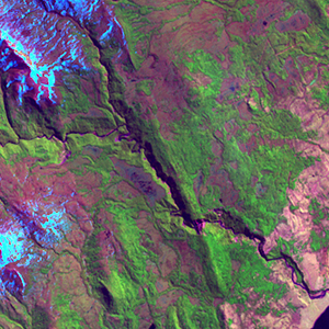
Path: 229; Row: 097
Data within tile: 100.0
|
|
Date: 1986/01/16
Cloud cover: 2.9
|
|
NDVI at image date: 100% of annual maximum
 Downolad image data [zip] Downolad image data [zip]
|
|

zoom |
|
|
Path: 230; Row: 097
Data within tile: 100.0
|
|
Date: 1986/10/06
Cloud cover: 12.6
|
|
NDVI at image date: 79% of annual maximum
Downolad image data [zip]
|
|
|
|
|
Landsat ETM+ (2000)

zoom |
|
|
Path: 229; Row: 097
Data within tile: 100.0
|
|
Date: 2001/10/16
Cloud cover: 8.8
|
|
NDVI at image date: 86% of annual maximum
Downolad image data [zip]
|
|

zoom |
|
|
Path: 230; Row: 097
Data within tile: 100.0
|
|
Date: 2001/08/04
Cloud cover: 15.8
|
|
NDVI at image date: 42% of annual maximum
Downolad image data [zip]
|
|
|
|
|
Landsat ETM+ (2005)

zoom |
|
|
Path: 229; Row: 097
Data within tile: 85.3
|
|
Date: 2004/11/09
Cloud cover: 13.1
|
|
NDVI at image date: 89% of annual maximum
Downolad image data [zip]
|
|

zoom |
|
|
Path: 229; Row: 097
Data within tile: 84.5
|
|
Date: 2005/03/01
Cloud cover: 0.0
|
|
NDVI at image date: 100% of annual maximum
Downolad image data [zip]
|
|

zoom |
|
|
Path: 230; Row: 097
Data within tile: 66.9
|
|
Date: 2005/02/20
Cloud cover: 0.0
|
|
NDVI at image date: 100% of annual maximum
Downolad image data [zip]
|
|

zoom |
|
|
Path: 230; Row: 097
Data within tile: 67.6
|
|
Date: 2005/10/02
Cloud cover: 2.7
|
|
NDVI at image date: 79% of annual maximum
Downolad image data [zip]
|
|
|