|
Landsat TM (1990)

zoom |
|
|
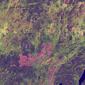
Path: 018; Row: 027
Data within tile: 100.0
|
|
Date: 1991/08/20
Cloud cover: 0.0
|
|
NDVI at image date: 99% of annual maximum
 Downolad image data [zip] Downolad image data [zip]
|
|

zoom |
|
|
Path: 019; Row: 027
Data within tile: 73.9
|
|
Date: 1988/05/14
Cloud cover: 39.2
|
|
NDVI at image date: 79% of annual maximum
Downolad image data [zip]
|
|
|
|
|
Landsat ETM+ (2000)

zoom |
|
|
Path: 018; Row: 027
Data within tile: 100.0
|
|
Date: 2002/05/22
Cloud cover: 0.0
|
|
NDVI at image date: 79% of annual maximum
Downolad image data [zip]
|
|

zoom |
|
|
Path: 019; Row: 027
Data within tile: 100.0
|
|
Date: 2000/08/27
Cloud cover: 0.0
|
|
NDVI at image date: 99% of annual maximum
Downolad image data [zip]
|
|
|
|
|
Landsat ETM+ (2005)

zoom |
|
|
Path: 018; Row: 027
Data within tile: 100.0
|
|
Date: 2005/08/26
Cloud cover: 0.0
|
|
NDVI at image date: 99% of annual maximum
Downolad image data [zip]
|
|

zoom |
|
|
Path: 019; Row: 027
Data within tile: 100.0
|
|
Date: 2007/05/03
Cloud cover: 1.2
|
|
NDVI at image date: 71% of annual maximum
Downolad image data [zip]
|
|
|