|
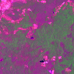
Landsat TM (1990)

zoom |
|
|
Path: 019; Row: 047
Data within tile: 100.0
|
|
Date: 1990/11/20
Cloud cover: 0.1
|
|
NDVI at image date: 100% of annual maximum
 Downolad image data [zip] Downolad image data [zip]
|
|

zoom |
|
|
Path: 020; Row: 047
Data within tile: 100.0
|
|
Date: 1988/04/27
Cloud cover: 93.8
|
|
NDVI at image date: 84% of annual maximum
Downolad image data [zip]
|
|
|
|
|
Landsat ETM+ (2000)

zoom |
|
|
Path: 019; Row: 047
Data within tile: 100.0
|
|
Date: 2000/04/21
Cloud cover: 0.0
|
|
NDVI at image date: 79% of annual maximum
Downolad image data [zip]
|
|

zoom |
|
|
Path: 020; Row: 047
Data within tile: 99.9
|
|
Date: 2000/03/27
Cloud cover: 0.0
|
|
NDVI at image date: 81% of annual maximum
Downolad image data [zip]
|
|
|
|
|
Landsat ETM+ (2005)

zoom |
|
|
Path: 019; Row: 047
Data within tile: 62.5
|
|
Date: 2004/02/28
Cloud cover: 0.0
|
|
NDVI at image date: 87% of annual maximum
Downolad image data [zip]
|
|

zoom |
|
|
Path: 019; Row: 047
Data within tile: 63.1
|
|
Date: 2005/10/28
Cloud cover: 0.0
|
|
NDVI at image date: 98% of annual maximum
Downolad image data [zip]
|
|

zoom |
|
|
Path: 020; Row: 047
Data within tile: 81.8
|
|
Date: 2005/01/04
Cloud cover: 0.0
|
|
NDVI at image date: 98% of annual maximum
Downolad image data [zip]
|
|
|